Map data and network
Section author: Xingmin Wang <xingminw@umich.edu>
Overview
Map data and network module (mtldp.mtlmap) is used to process OpenStreetMap data and convert it to a well-defined python class object. This module also includes a series of functions built on the network class including implementing network-related algorithms, plotting, etc.
Why map matters?
Map data and the network data structure is one of the most critical foundations for both the trajectory data processing and network analysis. As shown in the following figure, map data and network is usually the base for all the other data including the trajectory data, signal phase and timing (SPaT), and traffic demand and flow data, etc. Most of the data needs to be indexed by the map data before further processing; for example, the map data will be used for the trajectory map-matching. For the network flow data and the SPaT data, we need to know the mapping between the map and the data.

Therefore, mtldp.mtlmap provides a bunch of map data processing function including parsing the
OpenStreetMap data to a well-organized network data structure mtldp.mtlmap.Network, saving
the network data into different map formats including .osm(xml)/ESRI shapefile, and some basic
plotting functions.
Parsing the OpenStreetMap
The core of the mtldp.mtlmap is a OpenStreetMap data parsing function mtldp.mtlmap.build_network_from_xml()
that parses OpenStreetMap data to a well-organized network data structure mtldp.mtlmap.Network.
The following illustration shows the flowchart of this map data parsing function. The map data parsing
function can construct different layers from the OSM data including nodes, segments, movements,
and laneSets, etc.

The map data parsing and reconstruction is always about a trade-off between accuracy and precision.
The generation of a more accurate layer tends to have more errors since the original OSM data usually does not
have sufficient lane-level information including the assignment and usage, etc. Therefore, we divide the map data
parsing and generation into different modes with different output levels:
-
class
mtldp.mtlmap.MapMode(value) Mode selection for parsing the OpenStreetMap data
mtldp.mtlmap.build_network_from_xml().See map parsing flowchart for more information.
The mode in the lower row (more accurate mode) generate more layers than that of upper row, which means that it will also generate the layers that can be generated by the mode in the upper row.
Mode
Output layers
Applications
.MAP_MATCHINGSegment,Node,OsmWayTrajectory data map matching
.ACCURATELink,SegmentSplit trajectory into movements
.ROUGHLaneSet,ConflictPointBuild CTM model, etc.
Note
The OpenStreetMap data could be very complicated with many different corner cases, errors including
absent/wrong attributes/tags, unexpected topology, etc. Therefore, it is inevitable that there are many situations
that could not be parsed or recognized correctly using the current map data parsing function. To deal with this,
we might need to either manually fix some bugs or keep improving the current map parsing function. For now, the map
parsing function will output a log file with all the unexpected cases for users’ information.
Besides, the map parsing function will call mtldp.mtlmap.Network.build_networkx_graph automatically to get a
NetworkX graph object
according to different layers (segment, laneSet, link). This means that the implemented algorithms
(e.g., shrotest path, network partition) in the NetworkX can be easily adopted.
Map data edit and workflow
Since the map data parsing and reconstruction will inevitably involve some noise and errors, the manual edit would be helpful to deal with some complicated corner cases or some customized demand such as adding additional attributes or tags to the road segments. To accomplish this, the workflow of the map data should be considered carefully. The following figure shows different production flowcharts for the map data.

JSOM is a light-weight and easy-to-use open-source software that can help to view and edit the OpenStreetMap data. We recommend users to use this software to edit the map data before loading it to the data platform if needed.
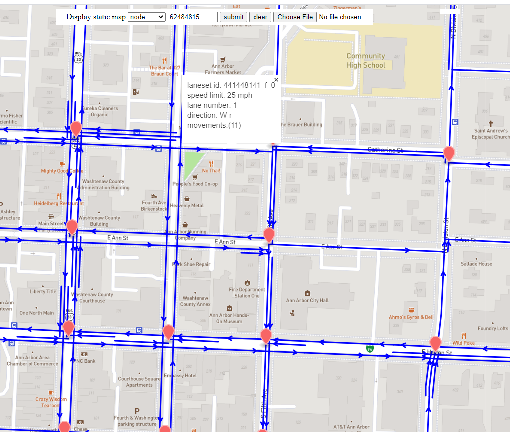
Map data visualization
We also create an easy web-based map data visualization tool hosted at
mtldp map web. This web can take the .json file as the input and
show the map data accordingly. The .json file can be generated using the mtldp.mtlmap.output_static_geometry_json().
Here is a screenshot of the website, you can choose different layers and click on the road segment to see the detailed information:
Network data structure
Note
The network data is designed as two versions: static network and network of certain time of day (TOD). The static network contains the static network topology and geometry. The network of TOD inherits all the static network information; besides, users can also dump the trajectory data as well as other data set into this network object to perform location-based study.
Static network
Name |
Class |
Content |
|---|---|---|
Network |
Class object for the whole network |
|
Nodes |
Class for the nodes in the network |
|
Links |
Road segment connects intersections composed of a list of segments |
|
Movement |
A movement is defined as a feasible in-link and a out-link at intersections |
|
Segment |
Road segment with homogeneous parameters ( |
|
LaneSet |
Class for a group of lanes that have the same downstream direction |
Note
All the road segments including Link, Segment, LaneSet are directed.
Network of TOD
The current classes extends the static network, all the other classes not included here remain the same with the static network.
Name |
Class |
Content |
|---|---|---|
Network of TOD |
|
Class object for the whole network with additional data of certain time of day |
Movement of TOD |
|
Class of the movement with data (trajectory, SPaT) of certain TOD |
Map functions
Core functions
Function |
Content |
|---|---|
Build the |
Utility functions
Reference
- Source code
- Tutorial